
For processors and surveyors
Export from DJI Terra, Agisoft Metashape, or your processing workflow, then host supported viewer-ready packages for clients without building a portal.
Launch with Dataset Pass, host viewer-ready drone data exported from DJI Terra, Agisoft Metashape, or your processing workflow, then give clients and asset teams one secure review workspace.
Built for processed, viewer-ready data from
Inspection AI
Sites
128
Assets
2,846
Inspections
1,392
Open issues
23
Team members
18
BYO data launch
Dataset Pass is the low-friction way to put one supported, viewer-ready dataset into SmartData. Dataset count is the main customer-facing limit; included storage is a fair-use infrastructure allowance.
BYO is for processed, viewer-ready hosted-view packages. Raw photos, DJI or Agisoft project folders, loose GeoTIFF files, loose LAS or LAZ files, OBJ or FBX assets, and arbitrary file drops need conversion or processing quoted separately.
Export from DJI Terra, Agisoft Metashape, or your processing workflow, then host supported viewer-ready packages for clients without building a portal.
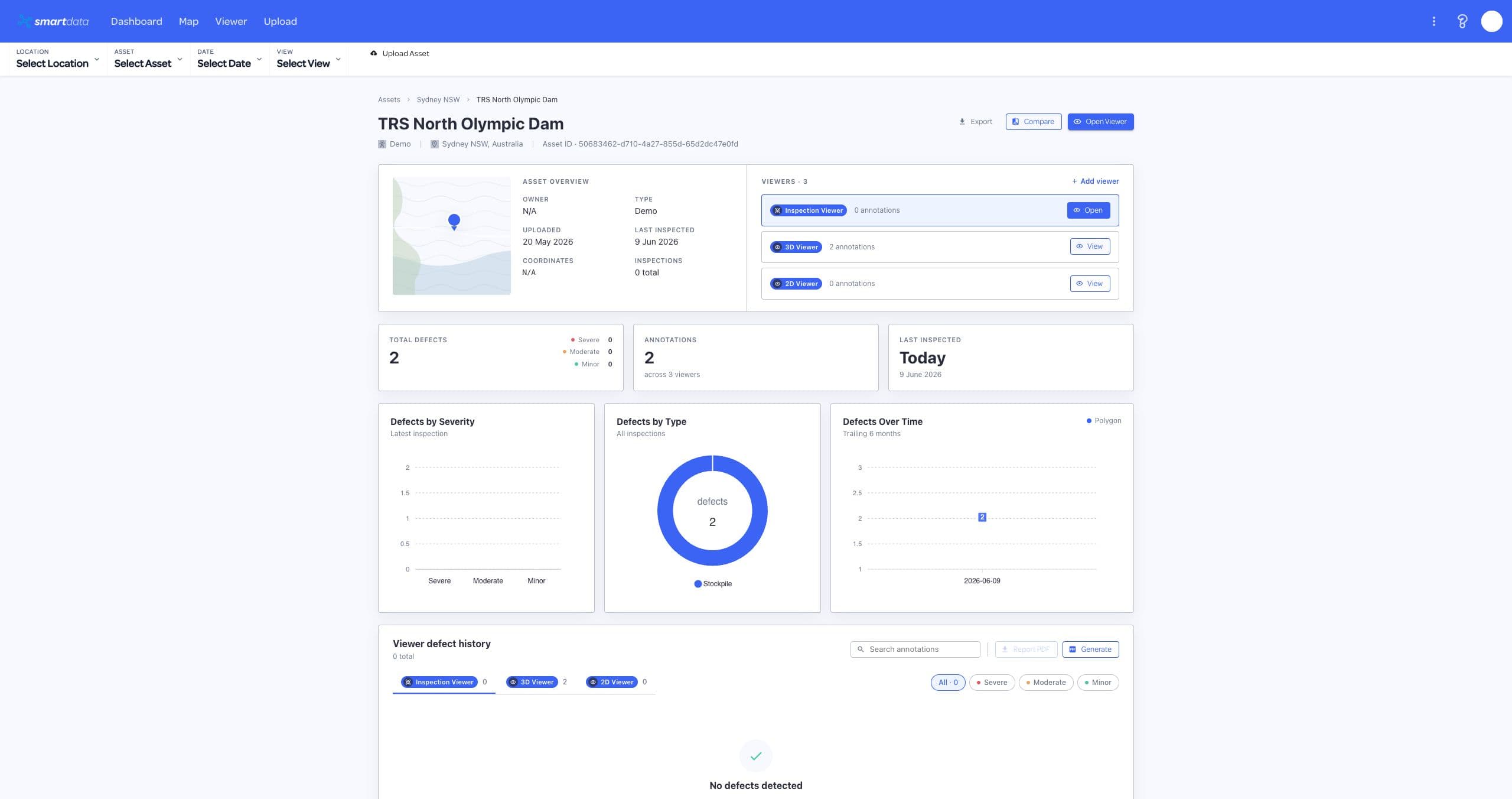
Give teams one trusted place to share, review, and revisit hosted drone datasets instead of sending files through ad hoc download links.
Built by National Drones / SmartData
Real hosted viewer workflows for teams that need to share and review trusted drone data, not another folder of files.
Public demo sandbox
Open the live sandbox to explore the SmartData viewer experience with sample inspection and asset data. The preview links directly to the live workspace so testers get the full viewer experience in a new tab.
 Launch demo sandbox
Move from raw drone capture to trusted decisions without losing context between file stores, inspection tools, spreadsheets, and reports.
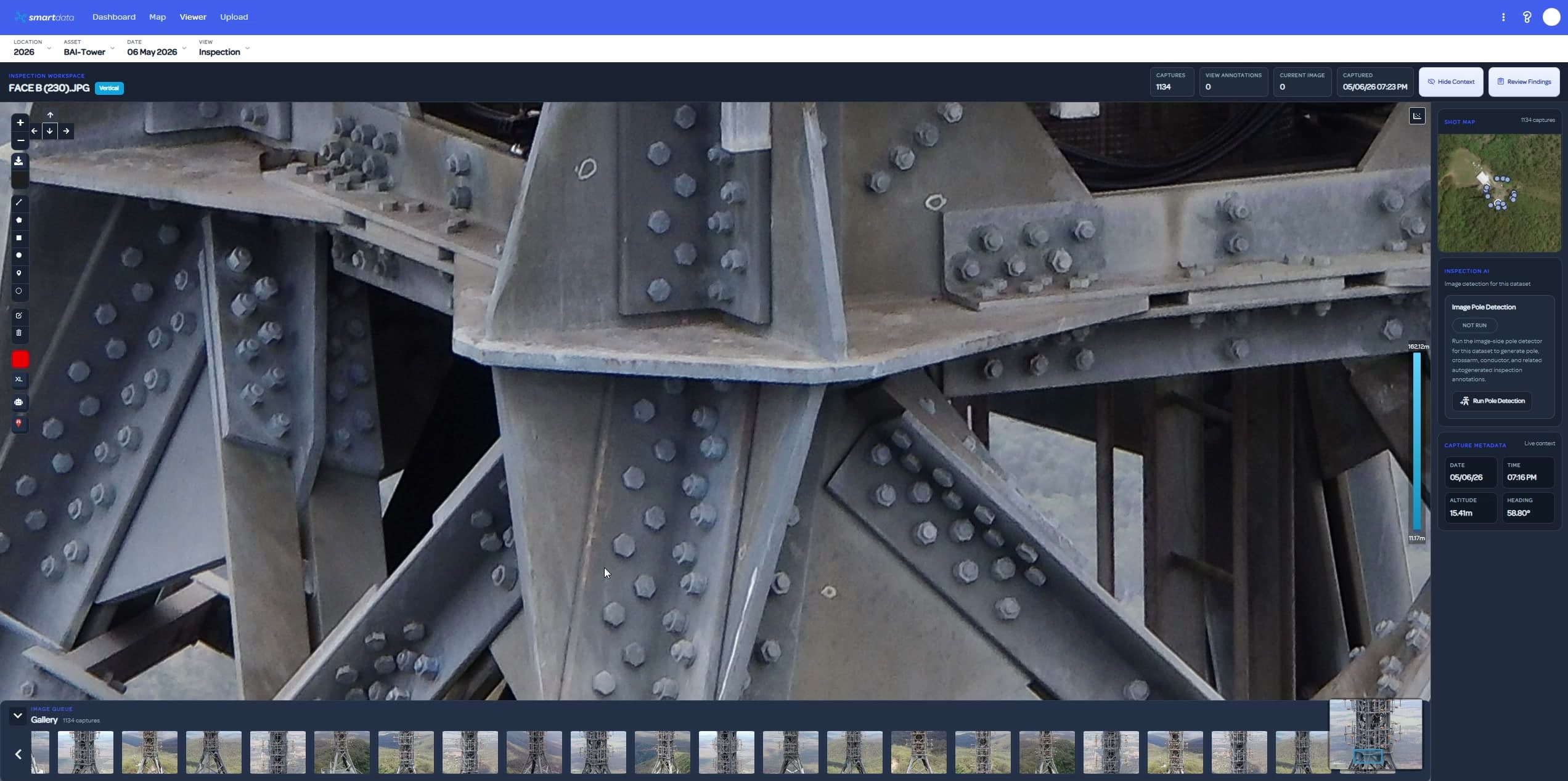
Review high-resolution imagery with AI-assisted detections, confidence signals, crop previews, and status workflows that keep field teams moving.

Move between 3D models, point clouds, terrain, and Gaussian Splat views so engineers can inspect complex assets from the right perspective.
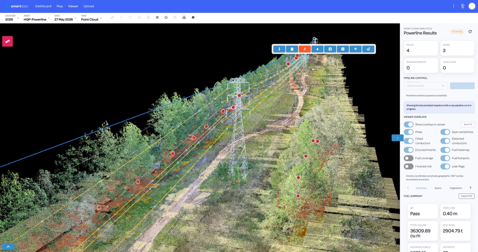
Surface corridor risks, vegetation issues, validation status, and exportable detections for utility and forestry operations.
Share annotated evidence, PDF reports, exports, notifications, and role-aware workspaces without scattering data across tools.
SmartData is designed for repeat inspection programs where the answer is not just a pretty model. It helps teams see change, assign review, measure risk, and ship evidence.
Upload
Host inspection imagery, maps, 3D deliverables, terrain, point clouds, and Gaussian Splat outputs in one project workspace.
Inspect
Use AI review, manual annotation, measurements, comparison views, and domain analytics to isolate risk quickly.
Act
Package results for stakeholders with reports, exports, shared links, review status, and team notifications.
Review queue
Measurements
Exports
The platform speaks the language of inspections, corridors, terrain, defects, vegetation, volumes, reports, and evidence. Each industry page connects the asset problem to the SmartData tools that support review, measurement, reporting, and team handoff.
Choose BYO hosting by the number of hosted datasets your team needs. Included storage is a fair-use infrastructure allowance, while processing, AI, analytics, and reporting are add-ons unless quoted separately.
The low-friction first upload option for hosting one processed drone dataset in SmartData.
For small teams hosting a few processed, viewer-ready drone datasets.
For active teams managing recurring uploads and wider viewer access.
For asset owners that need a contact-led platform arrangement rather than self-service checkout.
BYO is for processed, viewer-ready hosted-view packages including orthomosaic, Cesium 3D Tiles, point cloud, and Gaussian Splat. MVP storage overage is handled by manual account review rather than automatic overage billing.
Start with Dataset Pass for one viewer-ready upload, or speak with sales if you need processing, analytics, reporting, inspection AI, Powerline, ForestSmart, or enterprise hosting.